Welcome to the Sound
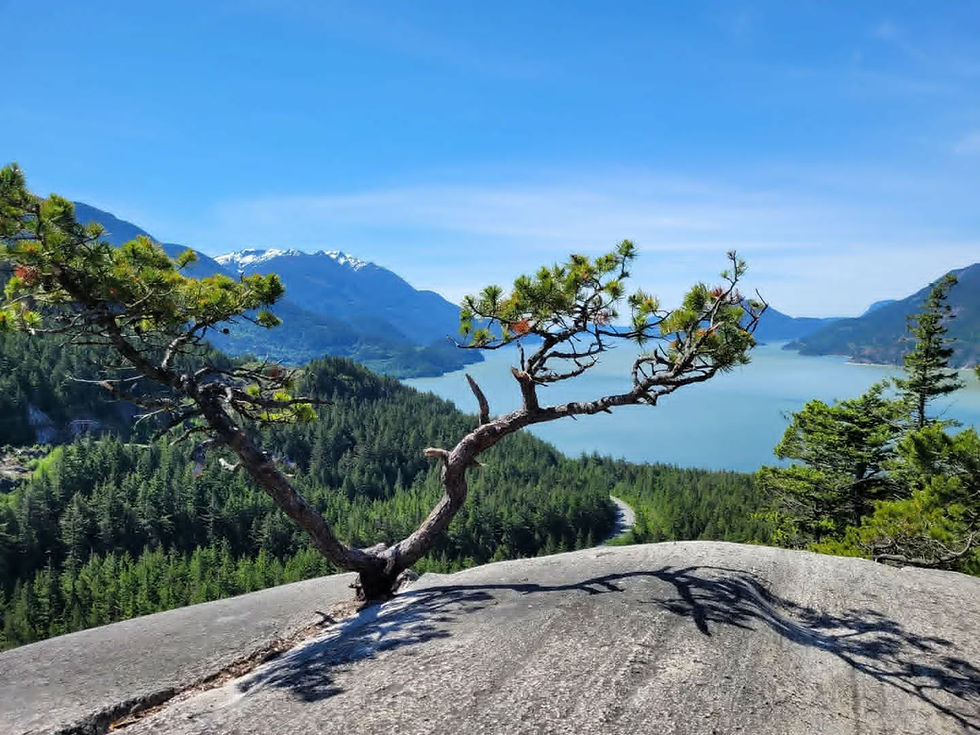
In the province of British Columbia, just north of the urban center of Vancouver, you will find a road leading you out into a dramatic display of cliffs plunging into the ocean below. A dance of greens, blues, and greys fill your senses, and if you’re lucky, may just catch the sight of a fin or a tail breaking the ocean blue, an eagle rising above salmon in claw, or the fuzzy face of mother bear poking her head out of the dense brush.
Welcome, to Átl'ḵa7tsem.
Welcome, to the Howe Sound.
Many pass by on their way to Squamish or further up to Whistler, or pivot to jump onto a ferry to find a promise of sunshine on the other side. Stopping briefly only for a photo op or to use the facilities found in communities whose name you’ll quickly forget.
It is difficult to comprehend what encompasses the Howe Sound. In the grand scheme of things, it is small, with its population scattered and separated by the water. Yet, it is the water that connects us. If we look at the Howe Sound watershed within the parameters set in the creation of a UNESCO biosphere region, it is “218,723 hectares [or] 2,187 square kilometres” (source: Howe Sound Biosphere). This includes the communities of Horseshoe Bay, Lions Bay, Furry Creek and Britannia along its eastern shores, Gibsons and Port Mellon in the west, Squamish at the head, and the islands of Bowen, Gambier and Keats, with some folks taking up residence on Bowyer and Paisley Island. These communities exist within the unceded territory of the Sḵwx̱wú7mesh Úxwumixw people, with a strong history and claims coming from the “Tseli-Waututh, Musqueam, Sto:lo, Shishalht, St’at’imc-Lillooet Tribal Council, In-shuck-ch, Katzie, Lilwat and First Nations within the Hul’qumi’num Treaty Group” (source: Howe Sound Biosphere).
In this first article, we will be looking at the landscape so many of us are lucky to call home. Giving us the lay of the land is geologist and storyteller, Dr. Bob Turner. A longtime resident of Átl'ḵa7tsem, Bob has not only borne witness to the recent changes that the Sound has underwent but has in-depth knowledge on the geographical structuring and ancient geological upheavals that formed it. Speaking on how the geology and geography contributed to the rich ecosystem we see today, Bob broke it down into two words: diversity, and fertility.
Diversity: Compression and the Rain Shadow Effect
The Howe Sound is known as North America’s Southernmost fjord. The end of a network of glacially carved coastal inlets found up the coastline of British Columbia.
“Fjords are remarkable in that they create deep bodies of water immediately adjacent to high mountains” states Bob, “you can have deep ocean waters, shallow ocean waters, coastline, river valleys, forested slopes, alpine areas, within ten kilometers of each other!”
Bob points out that this compression of landscapes and seascapes that occurs within a fjord is part of the reason why we see such an array of diverse habitats in one small pocket of our province. The other piece when it comes to diversity is because of Vancouver Island, and a phenomenon it creates for the southern fjords called a rain shadow.
A rain shadow effect is when mountains block off a large portion of the rainfall to an area. When storms come in from the Pacific, they dump a huge amount of rain on the west side of Vancouver Island.
“Then, they drop. And they basically suck moisture back up and essentially create this dry zone from eastern Vancouver Island all the way over to the mountain front here” Bob explains.
The result is that in the Howe Sound, there is a dry coastal landscape found in the outer islands, “however,” says Bob, “those airmasses rise as they go up the mountain front, and you get this very strong gradient of rainfall”.
This is something truly unique to the Howe Sound.
“Once you go north of Vancouver Island, there’s no rain shadow effect at all. The fjords [there] are wet from the front to the back, and here, we’ve basically got dry to wet.”
The impact Vancouver Island has on the weather makes this particular fjord unique. It adds to the variety of habitats that already exists within a compressed landscape and seascape, mixing in the difference between dry coastal ecosystems, and a temperate coastal rainforest.
Fertility: How Water Moves, and Where Lava Once Flowed
The rich ecosystem of the Howe Sound is not only due to its shape or location relative to Vancouver Island, but because of how it’s geological makeup, and the benefit of having two main rivers, ushers in a strong start to the local food chain.
The Howe Sound has two major rivers feeding into it, that in itself, is a rarity amongst coastal inlets. The Squamish River in the north funnels through, and from the southeast, the power of the Fraser River pushes key nutrients from the ocean depth north and into Átl'ḵa7tsem waters.
River plumes do two things, “they bring nutrients to the ocean from the land, so they fertilize the ocean that way” Bob explains, but there is also a hidden process. When the river plume moves water out to sea, it is dragging deep ocean water up. This deep ocean water is rich in nitrogen.
“When you deplete the nitrogen from surface waters, the plankton machine shuts off. When you replenish it…” Bob smiles, “the plankton kick back on.”
This, is vital. Plankton are the heavy lifters of marine ecosystems. Their nutritional value creating the base for aquatic food webs. While the term plankton can refer to visible organisms, it is mostly made up of microorganisms, including both phytoplankton and zooplankton.
“Phytoplankton captures energy from the sun and produces organic matter. Zooplankton… then eats this phytoplankton… and in turn becomes a resource for fish, jellyfish, birds and marine mammals” (source: Foundation Tara Ocean). But it is not just food, it supports entire ecosystems and is an indicator of a healthy ocean environment.
With the Squamish and Fraser Rivers, you have not one, but two rivers providing key nutrients to support the phytoplankton. But the rivers aren’t the only players in the nutrient distribution game. The Howe Sound after all was built not only by the receding of glaciers, but by the power of volcanoes.
Átl'ḵa7tsem has the most volcanoes out of any coastal fjord here in British Columbia. From Mt. Garibaldi to Mt. Cayley and their numerous of satellites, the geological composition of these volcanoes’ ushers in silica, phosphorous, iron, and other nutrients through the Howe Sound watershed.
“Most other rocks around here are granite. And, they’re resistant,” Bob shares, “they’re really stingy with the nutrients they release cause they break down slowly. Whereas volcanic rock breaks down quickly and in fine material.”
For how the volcanoes come into play with the Howe Sound’s rich ecosystem, Bob once again turns his eye to our plankton, specifically, diatoms. Diatoms are single-celled algae with silica shells. “They are responsible for an estimated 20-40% of global primary production, producing vast amounts of oxygen essential for life on Earth” (source: International Society of Diatom Research). Sequestering “an estimated 40% of oceanic carbon,” they aid in climate regulation “providing essential services that support life on Earth” (source: International Society of Diatom Research). They can be found in most marine environments but stand out in high concentrations in Átl'ḵa7tsem.
“I think that high silica into Howe Sound really drives diatoms” Bob ponders. Where other comparable fjord systems may have jellies at the base of their food system, which is not nutritious, diatoms reside at the base of ours. “I don’t know for sure if that’s all because of volcanoes, but I know we have diatoms, and the question is, is there something special going on in Howe Sound?”
The question if there is a correlation between volcanoes and the high concentration of diatoms in the Howe Sound highlights the need for more scientific research and funding for ocean science. Understanding how a productive ecosystem occurs in the Howe Sound is crucial, as not too long ago, it was considered a dead zone.
A Quiet Ocean
Dr. Bob Turner, who had moved to Bowen Island in 1989 with his wife, Rosemary, remembers 90s in the Howe Sound as a quiet ocean.
“Biggest thing, most exciting thing you’re going to see out on the water is a seal. Every once in a while, you’d hear about a sea lion, and that would be news” Bob reflects. This was due to the impact of industry on the area. Many of the existing communities within the Howe Sound got their start from taking the richness of the land and exporting natural resources abroad, or down the Sound and over to meet the demands of the growing metropolis of Vancouver. From the early 1900s to the early 2000s, pulp and paper, logging, and mining was the main source of employment. But the consequence of unregulated industry continues to be felt by the BC taxpayer, and the older population who worked with these toxic chemicals.
An example of one industry’s impact on one aspect of the Átl'ḵa7tsem ecosystem is the Britannia mine. Once known as the biggest source of copper in the British commonwealth, it also became the largest source of water pollution in North America. A chemical process called acid rock drainage flowed into the Sound, and the mine tailings, now the base of the Sea to Sky highway, seeped into the ocean, creating a slick of copper-laced water. Bob speaks on the impact this had on the juvenile salmon population that come down the Squamish River, “They are basically shoreline huggers, and they split… some go left and some go right, some follow the east shore, some west shore.” However, there was no way that the juvenile salmon who follow the eastern shore past Britannia mine could make it through the sludge coming out of Britannia Creek. “We were probably losing about half of the juvenile salmon. And that was just one species.”
Behind the scenes, progress was slowly being made, and then in 2006, two big changes occurred in the area. “Woodfibre shut down and the treatment plant at Britannia turned on and boom!” Bob exclaims “first whale swims into Howe Sound in 100 years.” While whales in the past have come in search of food only to be discouraged, what is key here is that they swam fully in, and have since stayed.
The return of whales is huge to an area that has been so deeply hurt, but most importantly, they start a conversation. Bob points to the Squamish nation story of Mink hosting a potlatch on Gambier Island, where Whale ends up stuck in the longhouse, forcing the other animals to stay (click here to listen to story). He recalls when he first heard this story, “the way the story was told is, that’s where we are right now. The whales came back, and they’re sort of forcing the conversation. Like, what are we going to do to protect this place?”
This conversation gave way to something few had in this area for a long time. Hope. Bob continues to speak on the remediation of the Howe Sound, “I think it’s not just recovery of the marine system, it’s the recovery of the human spirit to fight for the Howe Sound.”
Stories of Home
Bob’s advocacy for the Sound is reflected through his art as a storyteller and movie maker, allowing people to connect with the land.
“Geography and geology are about landscapes. Landscapes are home… I want to tell stories about the landscapes of home.” Recently though, for Bob, his concept of home is changing, as the Howe Sound in which he lives, cannot be healthy without the health of the Salish Sea being assured. This epiphany came in part by looking at a graph on the return of humpback whales in the Salish Sea, and Bob realizing that it mirrored the graph for humpbacks in the Howe Sound.
“I sort of said, okay. I’m going to take on my sense of home now as sort of the Salish Sea. And it’s a big home. It’s a hard to know home. And its not really my home, but I’ve sort of embraced it.” And as demonstrated through his work, Bob is more than up for the challenge of getting to know such a massive place and connecting all of us to it as well.
If you would like to dive more into the stories of Dr. Bob Turner, go to https://oursalishsea.ca/ or visit his YouTube channel http://www.youtube.com/@bobturner7642 to watch his films on the incredible ecology and geology found throughout the Salish Sea.
And if you would like to listen to the Squamish Nation story of Mink hosting a potlatch, or any of the other amazing Squamish and Musqueam stories that shaped this land, please click on the link to the Museum of Vancouver’s “Temíxw: Stories from the Land," a project done with Chief Ian Campbell that perfectly encapsulates how stories and geography are linked to create connection and facilitate knowledge. https://museumofvancouver.ca/temixw-stories-from-the-land
Comments